New month, new tropical storm
Many have wondered why this tropical season has been so quiet. Actually, it has been rather normal, we're simply remembering last year, which (all together now) was the most active Atlantic season in written history. Chris is the 3rd named storm this year; by this time last year we had 7 named storms, 3 of those became hurricanes, and 2 of those became major hurricanes. Compare to the long-term (1944-1996) average of 1, 0, and 0 respectively, indicates last year was, well, abnormal, and that this year is slightly ahead of normal.
On to Chris. Chris became the third tropical system this morning. He is located a couple hundred miles east of Antigua, and is a minimal (35 mph) tropical storm. Chris is moving toward the west-northwest at 9 mph. Tropical storm warnings have been issued for most of the Leeward Islands, and tropical storm watches are up for Puerto Rico, and the Virgin Islands. Chris is expected to pass north of the islands over the next couple of days. Strong intensification over the next two days is not anticipated (but remember, we're not too good at that yet).
The forecast is problematic, primarilly because our forecast models haven't correctly located the storm yet. Global forecast models typically take a few runs to figure out/lock onto where a new tropical cyclone is. Additionally, NHC will most likely fly a plane into Chris today, collecting more data to be loaded into the models. In other words, today's simulations will tend to be less accurate than those from tomorrow. This morning, many of the global models dissipate Chris in about three days, and take it south into the rugged terrain of Hispanola. Tomorrow's models might have a completely different story.
The forecast is also complicated by the other flows in the region. Below is a water vapor satellite image from around 6 AM ET this morning. The colors here represent the amount of water vapor in the atmosphere in the roughly 5-7 km altitude range. The color bar on the bottom right indicates the amount of vapor, ranging from brown (dry) to blue (wet). If you loop these images following the link on the right (dial-up unfriendly) you can get a sense of the flow patterns.
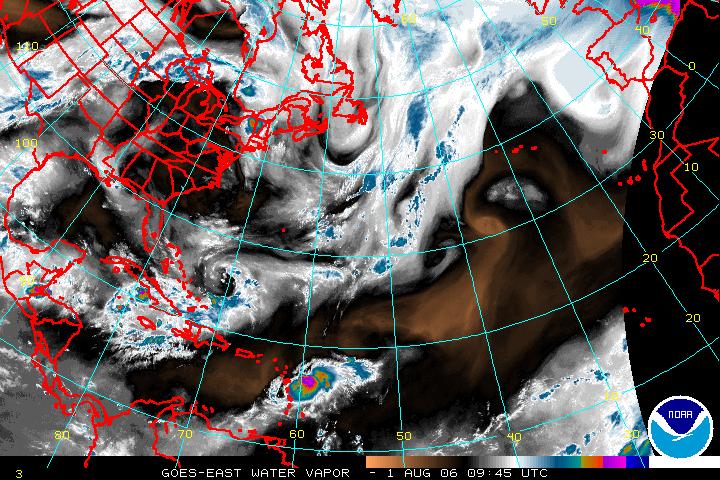
First thing of interest is that there's an awful lot of dry air surrounding Chris. This is not an environment conducive for major strengthening. Second is the presence of an upper-level low pressure system centered east of the Bahamas, extending south to Hispanola. The location of this low relative to Chris will also determine the forecast.
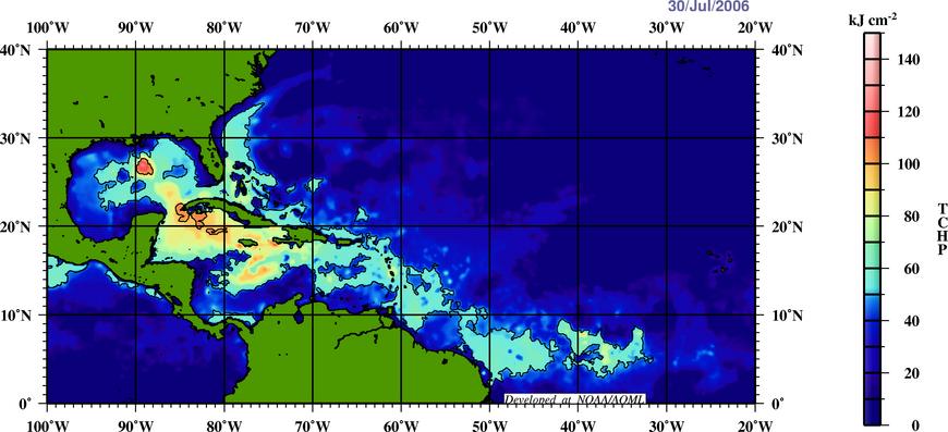
Another factor favoring minimal intensification is the oceanic heat potential, illustrated in the image below. Long story short, tropical storms need warm water, and this chart indicates where the warm water is. The light blues indicate where enough warm water exists to support a minimal tropical storm or a Cat 1 hurricane, while the reds indicate where major hurricanes could be supported. Chris is currently located in the light blue area, implying there is enough heat in the ocean to support no greater than a minimal hurricane.
One factor in favor of strengthening is that the wind shear near Chris has been decreasing over the last day or so. The global models forecast this shear to continue to decrease over the next couple of days. Extra points to those of you who have noted that these are the same global models that aren't accurately modeling Chris just yet.
The Hurricane center has not bought off on the weakening trend from the global models. The current track keeps the storm south of the Bahamas, but north of the Greater Antilles. The storm is forecast to be a strong tropical storm (about 60 mph) covering a fairly small area. It is too soon to determine if it will impact Melbourne or not, but it is something that bears watching.
posted by hodograph at 5:42 AM
![]()


0 Comments:
Post a Comment
<< Home